Afternoon Storms in Northern Guinea and Eastern Sengal Track Toward Coast

  • Oct 11, 2013

2013 October 11, 16:00 UTC: A westward moving impulse along the Inter-Tropical Convergence Zone (ITCZ) caused a large area of strong thunderstorms to develop this afternoon. The storms were located across northern Guinea and into Senegal and Guinee-Bassau.  Storms were moving into a very hot and unstable air mass. The storms were feeding off a very warm and unstable air mass located over the region. Temperatures were over 30C and some near 40C with high humiditiy.

A westward moving impulse along the Inter-Tropical Convergence Zone (ITCZ) is shown here with infrared satellite, and lightning data. Storms were moving into a very hot and unstable air mass.
ENcast hourly forecast shows that the rainfall experienced this afternoon was well forecasted yesterday.
ENcast hourly forecast shows that the rainfall experienced this afternoon in Mali was well forecasted yesterday.
Storm intensity is shown through a graph of lightning rate for a storm in NW Guinea. Rates were strong enough to cause a Dangerous Thunderstorm Alert to be issued.
The Guinea Total Lightning Detection System shows the speed, intensity and direction of strong storm.
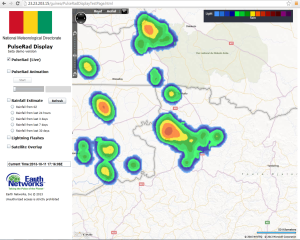
Simulated radar using the total lightning data is able to depict the strongest storms as they move out of northern Guinea into Senegal and Guinee-Bassau.