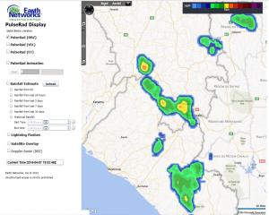
Rains Still Confined to Southern Regions of Guinea
7 April 2014 – 20:00 UTC: Rainy season rainfall continues to be hit and miss across the Guinee Forestiere region in Guinea. Areas of instability that produce rainshowers and storms have been occuring every few days, but most rain over the last month has fallen south of a line from Faranah to Kankan. Total rainfall in the last 7 days in this region has been from 25 mm to as high as 125 mm.

Meteorologists were tracking strong storms today in the region in an area northwest of Nzerekore that had the potential to produce dangerous thunderstorm winds and heavy downpours.
Dangerous Thunderstorm Alerts (DTA) issued by the National Meteorological Directorate were triggered by the detection of high rates of lightning being tracked by the Total Lightning Network. Automated polygons are generated by the Total Lightning system to indicate areas that could experience heavy rain, frequent lightning and gusty winds.


- Earth Networks Total Lightning Network has tracked severe storms today with lightning rates above 30 flashes per minute.


