Strong Storms Rumble Across Basse Guinea Toward Coast
29 October 2013, 17:00 UTC: Typical afternoon storm development has become severe across the northwest portion of Basse Guinea as storms developing across the hills and highlands have interacted with a steady sea breeze that has pushed inland from the Atlantic.

Guinea meteorologists have been monitoring the simulated radar system, PulseRad to determine the locations of the most severe storms. Very strong storms in the prefectures of Fria, Boffa and Dubreka have been determined to be severe based on measurements taken by the Guinea Total Lightning Detection Network.

The automated network generated Dangerous Thunderstorm Alerts (DTA) for several strong storms in the area. The lightning rates detected in these storms were determined to reach a frequency to cause the meteorologists to be concerned they would be producing flooding rainfall rates, gusty winds and very frequent lightning.
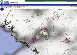

The strongest of the storms had automated Dangerous Thunderstorm Alerts issued based on thresholds exceeded determined by the Total Lightning Detection Network. The strongest storm was tracking north-northwest into Boffa and south of the city of Fria. This storm was likely producing flash flooding and gusty winds over 50 km/hr.


The storm had shown a steady increase in lightning frequency over the past hour. Lightning rates had approached 60 flashes/min. Meteorologist monitoring the storms have noticed a pulsing nature of the storm cells with storms weakening and dissippating over a time period of 2-3 hours. New storms continue to be expected to develop, track northwestward and decay till about 1 hour after sunset, after which all activity should decrease rapidly.

1 thought on “Strong Storms Rumble Across Basse Guinea Toward Coast”
Comments are closed.


le Chef de la station de Meteo de Fria a confirme ce mercredi 30 octobre le passage des orages au sud de la ville de fria avec des vents moderes a la station. les pluies qui sont tombees dans la soiree etaient de courte duree. Pas de degats enregistres.
Dr BAH M L Directeur Meteo Guinea