Strong Afternoon Storms Across Northern Guinea into Senegal
26 September 2013 15:00 UTC: This afternoon, Guinea meteorologists have been tracking an upper level disturbance moving westward across southern Mali and Northern Guinea. This disturbance has been producing a strong line of thunderstorms that have been generating very frequent lightning, gusty winds from 40-60 km/hr and very heavy downpours. Proxy radar has tracked the steady movement of the storms for the last 3-4 hours. Our forecast continue to call for these storms to maintain strength as the move through Eastern Senegal and Moyenne Guinea.

Rainfall has been ranging from 15 – 50 mm from these storms that have dropped the rain in about 1 hour.

The area of instability is moving into an area that has been very warm today and has plenty of instability to keep this line of storms very active with continued severe weather potential.
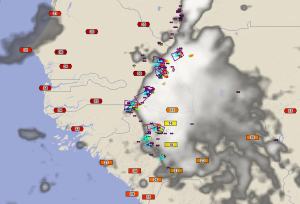

Visualization software shows total lightning detection at 3 p.m. local time and tracks of severe cells. Current air temperatures are plotted. Notice very warm and unstable airmass over Senegal. Purple polygons are Dangerous Thunderstorm Alerts indicating areas of the most severe weather in the area of storms shown in the infrared satellite image. Areas to the west will be affected by these storms over the next 4-5 hours with the continued potential for frequent lightning, winds gusting from 40-60 km/hr and flash flooding due to heavy downpours.


Visualization software shows total lightning detection at 3 p.m. local time and tracks of severe cells. Peak gusts are plotted. Purple polygons are Dangerous Thunderstorm Alerts indicating areas of the most severe weather in the area of storms shown in the infrared satellite image.


