Widespread Storms Drench Sierra Leone, Liberia
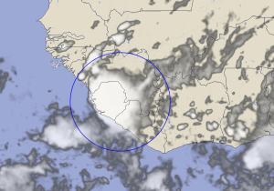
20 May 2014, 1800 UTC: An upper level area of instability along the Intra-tropical Convergence Zone (ITCZ) moved across the western coast of Africa today, triggering an active and strong area of thunderstorms early in the afternoon.


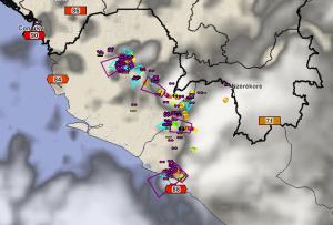
The storms were tracked by the Guinea Total Lighting Network as they developed and increased in intensity. The alerting system, triggered by the intense rate of lightning detected, issued warnings for parts of interior Sierra Leone for storms producing very heavy frequent lightning (rates over 40 flashes/min) and intense downpours of rain.

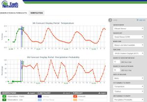
The storms had been well forecasted by the ENcast forecast system. Probabilities for thunderstorms and rainfall were over 50% yesterday and increased to near 100% by late morning today. The ENcast forecast for Monrovia in Liberia indicated very high threats for storms today and over the next several days.


By late afternoon and early evening, the storms had moved to the coast and started to develop in southwest Guinea, but the PulseRad radar system tracking accumulate rain was indicating the storms had dropped significant amounts of rain, specifically in Sierra Leone where 25-50mm of rain was common.


2 thoughts on “Widespread Storms Drench Sierra Leone, Liberia”
Comments are closed.


Translated:
In the evening of 20 May 2014 thunderstorm events were recorded in most of the prefectures located west of the Fouta and Lower Guinea in Conakry in particular. Strong winds uprooted trees, houses blown in Conakry and Koundara or the shingles off weather station building and the roofs of mosques have been swept away. There has been no loss of human lives. The meteorological department had reported in its bulletin the development of thunderstorms that runs along the west facade of the Atlantic Liberia south of Guinea Bissau.
Dr M L BAH National Director of Guinea Weather
Dans la soiree du 20 mai 2014 des manifestations pluviorageuses ont ete enregistrees dans la plus part des prefectures situees a l’ouest du massif du Fouta et en Basse Guinee notamment a conakry .
Des vents violents ont deracine des arbres, decoiffe des maisons a Conakry et a koundara ou la toiutre de la station meteorologique et les toits des mosquees ont ete emportees. Il n’ya pas eu des pertes en vies humaines. Le service meteorologique dans son bulletin avait signale le developpement des orages qui ont longe toute la facade ouest de l’atlantique du liberia au sud de la Guine Bissau.
Dr BAH M L Directeur National de la Meteo Guinee