Winter Forecast 2020-21: Watch the Winter Outlook
- Nov 12, 2020
Our Earth Networks Meteorologists revealed their 2020-21 Winter Forecast during our Winter Outlook Webinar on November 12, 2020. Keep reading to watch the recording and learn what to expect!
The winter weather outlook is an important one, as it helps us prepare for the three coldest months of the year and into the early spring. What will temperatures and precipitation trends will the lower 48 states see this year?
We know 2020 has been tough, but keep the faith! There doesn’t seem to be anything too crazy in the forecast for this winter. Keep reading to get the main points, or watch the entire webinar below.
You can also download the slides and go through them on your own.

Winter Outlook Leading Factors
The Earth Networks Winter Outlook meteorology team said there are three main drivers of this year’s winter weather forecast. Here’s what they are and how much they factored into their forecast:
- El Niño-Southern Oscillation (ENSO) 40%
- Best Matched Winters (Analog Years) 30%
- Decadal Trends (Temperature & Precipitation) 30%
ENSO
What is ENSO?
Have you ever heard a meteorologist say the term “ENSO,” or the phrase “El Niño Southern Oscillation,” and wonder what they were talking about?

ENSO is periodic, cyclical warming or cooling of the equator With all the crazy weather. El Niño is the warming cycle and La Niña is the cooling cycle.
What does ENSO have to do with the Winter Outlook?
It all has to do with the temperatures. We know winter gets cold, but how cold it gets has a lot to do with what phase of El Niño we’re in.
Will it be an El Niño, La Niña, or Neutral winter?
This winter our meteorologists are expecting the La Niña we’re currently in to continue throughout the winter. This means the equatorial sea surface temperatures will be below average.
La Niña Winters
You can expect three main things when you have a La Niña winter.

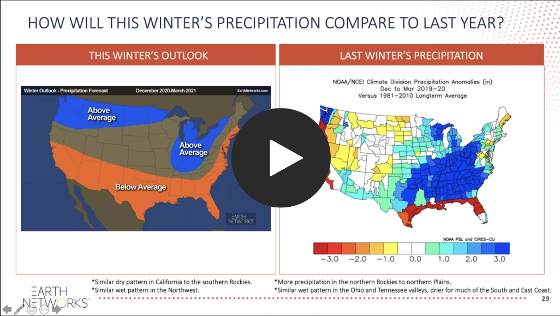
1. From the Northwest to the Upper Mississippi Valley, you can expect a wet and cooler winter. Precipitation, especially in the mountains, will consist of snow.

2. The second thing you can expect is dry and warm weather for much of the South. If you take a look at the map above, you’ll see that La Niña winter’s typically bring the warmer weather from Texas through the East Coast.

3. The third and final thing you can expect from a La Niña is wetter weather in the Ohio Valley area.
Snowfall During La Niña Winters

La Niña also impacts a winter season’s precipitation.
Regions including the Northwest, northern Rockies, and Upper Mississippi River to interior New England will most likely see more snow that average during winter 2020-21.
On the over hand, the southern Rockies, Southwest mountains, Ohio Valley, and Mid-Atlantic will see less snow than average this winter.
Analog Years
Which years most closely resemble our 2020-21 Winter Outlook? There three analog years our meteorologists used to create this outlook:
- 2005-06
- 2007-08
- 2010-11

Start watching the webinar recording to learn more about how analog years factored into our 2020-21 Winter Outlook!
Decadal Trends
In our webinar, we looked at data from the last 10 winters across the U.S. to help us get a better idea of what this winter might look like. As you can see from the Temperature Department from Average map below, most areas in the U.S. have been warmer than normal throughout the winter months.

There is more variety in terms of precipitation, with California and the South seeing less precipitation while the Northwest and Mississippi Valley saw more winter precipitation.

The Earth Networks 2020-21 Winter Outlook

Northern Tier
An active northern tier storm track will produce below-average temperatures. Severe cold blasts will be far and few between. Upstate New York and interior New England will see more snow than average.
Southern Tier
The Southern tier will stay warmer than average due to active storm track staying far north. Daytime highs will likely be warmer than average on many occasions due to lack of cloud cover. The Southern Tier and Interstate 95 corridor will see a drier than average winter.
Central
We’ll see near average temperatures from the interior Northwest into the central Plains, Midwest, Ohio Valley and Great Lakes. There will be an active storm track in the Ohio and Tennessee valleys and Great Lakes. We’ll also see less snow than average for the Ohio Valley but near to above average snow likely for the Great Lakes.
The West
Drought will intensify across California, the Four Corners, Southwest and southern Rockies. Wildfire danger will be significant during any Santa Ana wind events. We expect more snow than average expected for the Cascades, northern Rockies, northern Plains and Minnesota Arrowhead. The Northwest Coast will see more rain than average.
Watch Our Winter Forecast Webinar
Want to watch the entire Winter Outlook Webinar? Get started below! The webinar recording is free to watch, and you can even download the slide deck if you’d like to go through it at your own pace.
Common Winter Weather Threats
Freshly fallen snow and crystal clear icicles are beautiful sights, but don’t let that fool you. While beautiful, winter weather is also downright dangerous.
Now that you know what to expect this year, the next step is refreshing your winter weather safety. If you don’t have commercial weather tools at your organization that help you manage winter weather threats, click the link below to get in touch with one of our experts who will help you build a comprehensive plan.
Snowstorms and extreme cold are two of the most dangerous forms of winter weather.

Some of the most common winter weather threats include:
- Car accidents
- Hypothermia
- Frostbite
- Carbon monoxide poisoning
- Heart attacks (from overexertion while shoveling)
Learn more about the most common winter weather risks and how to protect yourself on our blog.
Winter Weather Safety Tips

You can get ready to face winter weather threats with these winter safety tips:
- Stay off roads
- Stay indoors
- Dress warmly
- Prepare for power outages
- Use generators only outside and away from windows
- Listen for emergency information and alerts
- Look for signs of hypothermia and frostbite
- Check on neighbors and coworkers
More Seasonal Outlooks
Here at Earth Networks, our meteorologists love to put together seasonal outlook webinars to help everyone – not just our customers – plan for the weather.
We’re committed to helping our friends at the National Weather Service (NWS) build a Weather-Ready Nation , and believe these webinars are a great way to make sure everyone in the U.S. knows what to expect.
Besides the Winter Outlook Webinar, we give other important forecast presentations throughout the year, including:
🌀Tropical Outlook
🌪️Spring Outlook
☀️Summer Outlook
1 thought on “Winter Forecast 2020-21: Watch the Winter Outlook”
Comments are closed.


nice blog. thank you so much.